Downhill/Uphill: A Mountain and an Academical Village–Part 1

 “Parcels 1A and 1B” may not have a familiar ring, yet the contributions of this land throughout the University of Virginia’s history are significant. In this article, authors Nancy Takahashi and Garth Anderson explain the long-standing relationship between two tracts of land in the life story of UVA. Nancy Takahashi is a Distinguished Lecturer and Director of UVA’s Graduate Landscape Architecture Program in the School of Architecture. Garth Anderson is the Facilities Historian in UVA’s Geospatial Engineering Services, Facilities Management.
The following excerpt is Part 1 (of 2) of the article “Downhill/Uphill: Material Flows Between a Mountain and an Academical Village” by N. Takahashi and G. Anderson. Landscript 5: Material Culture Assembling and Disassembling Landscapes. (2017) Berlin: Jovis Verlag.
Look for Part 2 of this article. Listen to the Lifetime Learning podcast “Thomas Jefferson’s Plan for Mount Jefferson to Sustain his Academical Village” featuring Nancy Takahashi.
Part 1 (of 2)
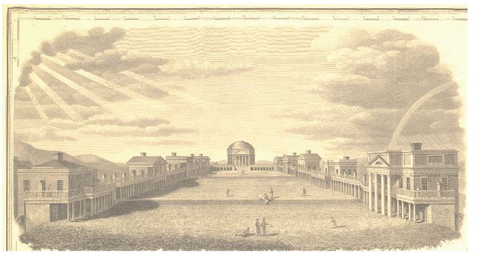
Thomas Jefferson’s Academical Village at the University of Virginia has long been celebrated as a visionary model of an integrated classroom and residential community of students and faculty. The Village’s lawn is the central organizing figure of the 43.75-acre parcel purchased in 1817 by the governing Board of Visitors (BoV) of the Central College, soon-to-be named the University of Virginia. To the north is the Rotunda which originally housed the library and classrooms. “The Lawn” is a series of terraces stepping down and southward to an open view of the Southwest Mountains. Flanking both sides of the Lawn are rows of student rooms, punctuated by ten larger “Pavilions,” which housed the ten original faculty and families, and also served as classrooms on the ground floor. Behind each Pavilion sat a serpentine-walled garden originally intended as a private utility yard for the resident faculty families, where they could work and raise food. Conjoined residential quarters, teaching spaces, and productive gardens, all surrounding a public open green, created a model of a self-sufficient community of students and teachers living and learning together—a vision Jefferson famously coined his “Academical Village.”
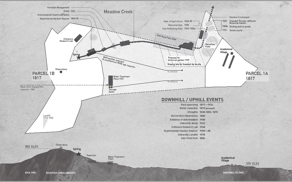
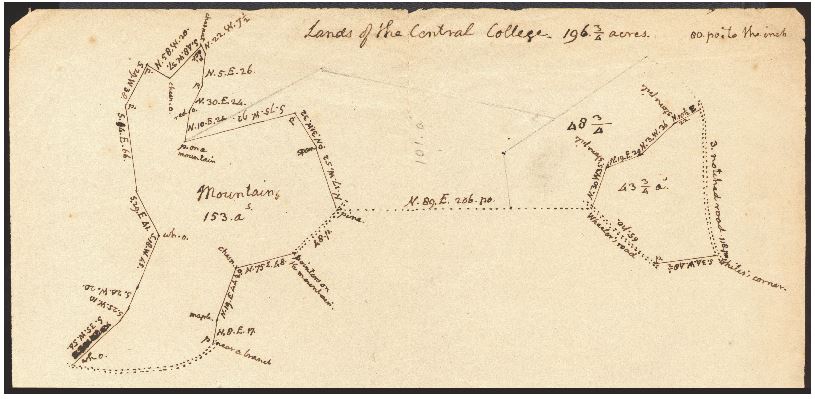
Less known is that the original land purchase for the college actually included two land tracts—Parcels 1A and 1B. Parcel 1A was a cleared, farmed parcel on which Jefferson’s Academical Village was built. Parcel 1B, a discrete parcel roughly a quarter mile to the west, was a 153-acre wooded hill tract, labeled simply as “Mountains” on the land survey that Jefferson drew in 1817. On June 23, 1817, the sale of these two noncontiguous parcels was executed for a price of $1,421.
Acknowledgement of the second “other” parcel has been evidenced over time in artist renderings that have been created of the University since its inception. The illustrations typically foreground the Academical Village, with the wooded mountain residing quietly behind. The mountain, rising roughly 290 feet above the uppermost terrace of the Lawn, is portrayed as a topographic counterpart to the domed Rotunda, its rural wooded aspect in contrast to the village below.
While the University’s spatial and mythic memory is imprinted with the mountain backdrop, little has been written about this other land tract. Two hundred years after the founding, the once discrete tract Parcel 1B is now fully integrated into the fabric of the University Grounds by roads and twentieth-century buildings which occupy the lower slopes of the once isolated mountain. The higher elevations, however, have evaded the pressures of University expansion and exist as the quiet forested domain of a handful of research faculty and recreationists. At first glance, the mountain appears untouched. Yet, a walk up the hill and a look into the history of artifacts and buildings on Parcel 1B reveal a significant and fascinating history of occupation.
This paper discusses the unrecognized contributions that Parcel 1B has played throughout the University’s history from its founding to current times. The long-standing relationship between the two tracts tells a story of material dependency based on the everchanging needs of a growing teaching and research institution. Over time, pure and life-sustaining materials—along with covert and lethal ones—flowed back and forth uniting the two pieces of land in the life story of UVA. History reflects periods of neglect, if not abuse, toward Parcel 1B; but in the twenty-first century, the wooded mountain tract reasserts its material value to the institution. Jefferson’s insight in purchasing the mountain tract for its resource wealth has proved critical to the success of UVA, although history illustrates how changeable the material flows would be over time—in ways that even Jefferson never could have anticipated.
- Stay on Track: Turning Resolutions into Results
- From “Jimmy Who?” to “What Would Jimmy Do?”
- Washington’s Bold Gamble: Christmas Day 1776
- Increasing Your Impact With Planned Giving
- UVA Club of Boston: UVA Men's Basketball Game Watches
- UVA Club of New Mexico: Cavs Care - Roadrunner Food Bank